Geographical Surroundings
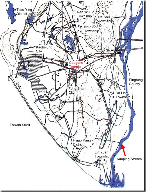
The Kaohsiung Plain is located in the southwestern part near the Central Mountains in Taiwan. In Ching Dynasty, the Kaohsiung Plain ran across Kaohsiung City and Kaohsiung County, namely Fong Shan, Naio Song, Da Liao, Lin Yuan, Da She and Ren Wu in Kaohsiung County, together with the administrative districts like Nang Zi, Zuo Ying, Ku Shan, Shang Ming, Ling Ya, Chiang Chen, Xin Xing, Chiang Jing and Xiao Gang in Kaohsiung City nowadays. The area mentioned above is adjacent to the Caogong Canal belonged to the Farm Irrigation Association of Kaohsiung Taiwan.

(picture provided by Mr.Wen-Chien Chegn)
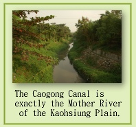
Caogong Canal used to be one of 3 major hydro-engineering constructions in Taiwan during Ching administration. Its fame could be compared with the Liu-Gong Canal in Taipei City and Ba-Bao Canal in Zanghua County. Among the 3 irrigation canals, it was the only one excavated by government. The canal runs throughout the Kaohsiung Plain and it is exactly the major water supply source of agriculture, industry and civil consumption. Caogong Canal is also the Mother River for people living in Kaohsiung City.
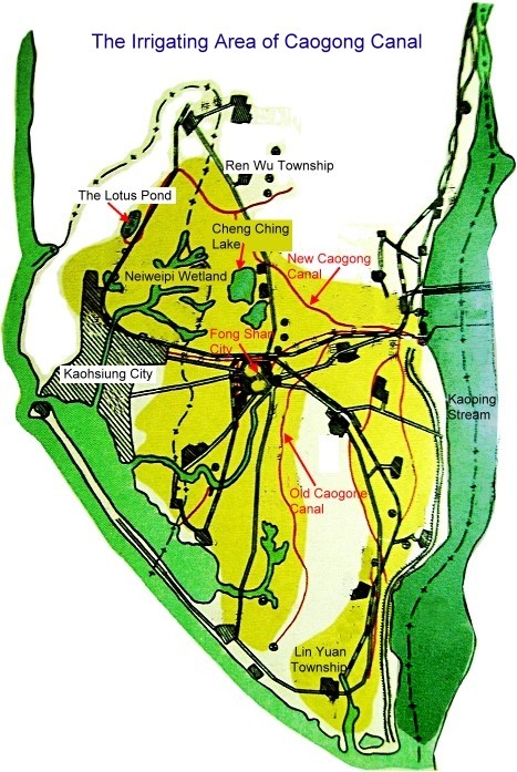
Caogong Canal enjoys its high historical
reputation among the hydro-engineering constructions in Taiwan with irrigating
range including as below. The north boundary is delineated by the Hojing
Stream extending to Ling Ko. The northeastern corner is next to Da Shu.
The eastern and southeastern boundary is separated by Kaoping Stream.
The western and southwestern boundary extends to Taiwan Strait. The southern
boundary reaches the plow-shaped estuary of Kaoping Stream. The irrigating
area forms like a triangle and the Kaohsiung City is covered within the
irrigating area of Caogong Canal.

(Picture provided by Mr.Wen-Chien Chegn)
In view of longitude and latitude, the northeastern corner of this area is located at east longitude 120¢X26'36" and north latitude 22¢X46'20". The southern corner (the estuary of Gao-Ping Stream) is located at east longitude 120¢X23'11" and north latitude 22¢X30'03". The water-introducing mouth of Caogong Canal (Jiu Qu Tang) is located at east longitude 120¢X25'32" and north latitude 22¢X39'58".
About the terrain and landform, this area shows downward trend from high hills in the northeast area to low coastline in the southwestern area. Thus, even when the main water path and branch water paths of Caogong Canal were started to dig without any precise instruments available, the canal design still could take good control of terrain height variances and make most of the extending ditches along the isoheight contour stably under prudential consideration so that water could run through wider areas and finally flow into rivers or ocean.
According to the past historical records about this area made by the Central Weather Bureau, the rainfall abruptly increases from May and then suddenly decreases after September. The rainy season starts from May to September, while the dry season begins from November to April of the next year. The annual precipitation is averaged at 1680mm with the highest precipitation of 421.5mm in June and the lowest precipitation 8.4mm in December. Most rainfall concentrates within the typhoon season from June to August. The annual average precipitation of this area roughly occupies 66.98% of the overall average precipitation (2510mm) in Taiwan Province.
About temperature, the average temperature within this area is 24.4 centigrade and the temperature changes fiercely during summer and winter. The distribution of rainy seasons is also uneven. Furthermore, with the annual average precipitation below the overall average precipitation in Taiwan Province, the well-developed irrigating facilities become the premise determinant for agriculture management.
¡@
Reflection

At the early beginning, the construction of Caogong
Canal was aimed to solve the problem of water shortage. When water shortage
causes starvation, people were forced to commit robbery, badly resulting
in the problem of public security. After the construction of this canal
was done, numerous problems were solved. It could be clearly seen that
the agriculture irrigation should never be ignored. We spent totally 4
days finishing our field-investigation to all the river basins of the
Caogong Canal and started to know the broad irrigation areas covered by
the Caogong Canal. However, within our visit to these river basins, we
found there had been numerous irrigation ditches dried and polluted with
stinking water. Because of so many damaged water courses, the original
irrigation areas of the Caogong Canal have been reduced remarkably and
most damage can be ascribed to human behaviors. The Caogong Canal used
to be the mother river of the Great Kaohsiung Plain with the relation
intimate to Kaohsiung inhabitants. However, currently, we only find man-made
pollution and this is very moment to take prudential review. Meanwhile,
to revive the Caogong Canal, we should spend more efforts than usual.
|

