| Speaking
of the trace of development of Zhong-shan District, we should
start from Yuanshan. Yuanshan is a hill situated on the west
side of Zong-shan North Road by KeeLung River. This is a central
area where our ancestors went fishing and hunting for living.
From Taiwan Shrine to Grand
Hotel
In 1901, in memory of Yoshihisa Shinnoh(a member of Japanese
Royal family)who died in suppressing Taiwanese resistance
against Japan, Japanese built the first official shrine, Taiwan
Shrine, on Jiantan Hill in the Dazhi Area. At the end of Japanese
colonial regime, Taiwan Shrine became an important place to
initiate war propaganda for Japanese Government. In 1975,
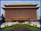
Taiwan's National Government tore up the Taiwan Shrine and
built a 14-story palace-like architecture, the world-famous
Grand Hotel. More than 200,000 carved dragons can be seen
inside and outside the architecture of the hotel. That's
why Grand Hotel was also called the “Dragon Palace.”
 |
 |
 |
 |
| The
first manager of Grand Hotel (retired) |
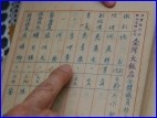
Transference
List of Grand Hotel 50 years ago |
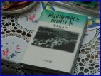
Colonial
Jinya and Imperial Japan |
Grand
Hotel |
| Information
provided by He Shih Geng ,Photos by Li Jyun-Jhih |
Photos by
Li Jyun-Jhih |
The
Origin of the Name “Dazhi”
KeeLung River flows in the central north of Taipei Basin. After
curving past by Dazhi and Jiantan Hill, a deep pool was formed;
therefore this area is called Jian-tan (note: “tan” means
“deep pool” in Mandarin).The name Dazhi Village first appeared
on the map of Taiwan in 1684 (during Kangxi Emperor's reign
in Qing Dynasty). Because after the winding KeeLung River flows
into this area, its river course becomes very straight and wide.
That's allegedly how this area got its name-Dazhi (Da means
“large”, while zhi means “straight” in Mandarin.)
 |
 |
 |
 |
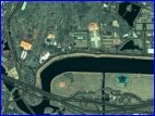
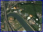
| Satellite
Image of KeeLung River in Dazhi Area |
Satellite
Image of KeeLung River in Dazhi Area |
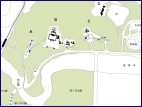
Icon
C indicates the location of the Martyrs' Shrine |
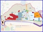
Map
of Dazhi District |
| Source:maps.google.com |
Source:Colonial
Jinya and Imperial Japan |
Source: Zhong-shan
District Office |
The
Formation of Dazhi District
During Japanese Occupation, in order to built a jinya (temple
of heaven) on Jiantan Hill, Japanese government levied the entire
surrounding neighborhood. Japanese government also planned this
area as barracks to station its troops and police guards. These
Japanese barracks were later inherited by National Government.
Added by the fact that former and incumbent high officials chose
to reside in this area, Dazhi District has gradually taken its
shape.
Unique Environment of Zhong-shan
District
Situated in downtown Taipei, Zhong-shan District was bestowed
with the most unique surroundings in Taipei. Lush hills, a beautiful
and grand river like KeeLung River which are hard to find in
the Taipei city jungle. Zhong-shan District is the district
that has the most parks in Taipei City, including Xinshen Park,
Zhong-shan Fine Art Park, Rongxin Garden, etc. It is also a
commercial district, filled with night markets, malls, and luxurious
department stores.
 |
 |
 |
 |
| Taipei
Fine Art Museum |
Dajia
Riverside Park |
Far
Eastern Geant Department Store |
Miramar
Entertainment Park |
| Photos
byLi Jyun-Jhih |
Website Translated
by Ou Yang Pei-ting(  Top )
Top ) |
|


)
)
)
)
)
)
)
)
)
)
)
)